Home Chiang Rai Thailand Chiang Rai Hotels About
Home  ›  Thailand  ›  Chiang Rai  ›  Day Trips
🏞️ Chiang Rai Day Trips · 2026

Wake before dawn for Phu Chi Fa's mist
then sip tea on Doi Mae Salong

Chiang Rai's best scenery isn't only in the city — it's up on the mountains around it. The sunrise sea of mist at Phu Chi Fa, a Yunnanese-Chinese tea village on Doi Mae Salong, the three-country point on the Mekong, the flower gardens of Doi Tung, and the province's tallest waterfall. All are day trips from the city, and we tell you plainly which can be done before dinner, which deserve an overnight, and which need a car.

Why Chiang Rai is a great base

The city sits in the middle, the mountains and the Mekong all around

The three coloured temples in town — the White Temple, the Blue Temple and the Black House — are what bring people to Chiang Rai. But once you've seen them, the thing that makes people fall for the north is what surrounds the city. Chiang Rai is Thailand's northernmost province, set among high mountains, tea plantations and the point where three countries meet on the Mekong River. The town itself is small and walkable around the clock tower and night bazaar, but the genuinely exciting stuff is a drive up into the hills.

One thing to know first: Chiang Rai has no train (the Northern Line ends at Chiang Mai) and no BTS/MRT metro. Getting around the province runs on your own car, a hired car with driver, a rented scooter, songthaews and tours. Many of the sights sit on winding mountain roads — frankly, most of these out-of-town trips are far easier with a car. The six below are the ones we think earn their place, ordered by popularity, with the real distance, how to get there, and which fits one or two spare days. For the wider picture in town and out, read our Chiang Rai attractions guide.

🗺️
Plan first
One spare day? The Golden Triangle and Chiang Saen. Two days? Add Phu Chi Fa or Doi Mae Salong — split your time Mekong side and mountain side
See the Chiang Rai guide →
6 day trips

Ranked by popularity — out of the city and up the mountains

Ordered by how popular they are, with an honest note on which is half a day, a full day or an overnight, which needs a car, and a dry-season haze warning for the mountain viewpoints.

Tea plantations on Doi Mae Salong, Chiang Rai — rows of oolong tea curving along green hillsides with a winding dirt track cutting through the slopes 1
Doi Mae Salong / Santikhiri
Yunnanese-Chinese village · ex-KMT soldiers · tea · ~65 km northwest

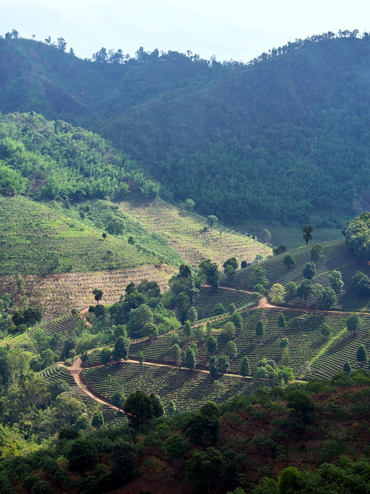
If you want a slice of China without leaving the country, Doi Mae Salong is it — a mountain village settled by the descendants of Chinese Nationalist (Kuomintang) 93rd Division soldiers who fled Yunnan after 1949, came through Burma, settled here, and were later granted Thai citizenship. To this day the people on the mountain speak Yunnanese Chinese, eat Yunnanese food, and farm high-quality oolong tea across the hillsides. The village's official name is Santikhiri.

The highlights are walking the tea plantations and tasting fresh oolong at the tea houses, the morning market with its mantou buns and braised pork, climbing to the Phra Boromathat Chedi Srinagarindra on the summit for the best view, and visiting General Tuan's mausoleum. Come in late December to January and the wild Himalayan cherry blossom turns the whole mountain pink. Around the hills are Akha and Lahu villages too.

Getting there: Drive or hire a car with driver from Chiang Rai ~1.5 hr (winding mountain road) · or bus to Mae Chan first, then a local songthaew up the mountain
Distance: ~65 km northwest of the city
Entry: Free to visit the village/plantations · tea tasting and the chedi are free (a small fee for some lookouts/cable cars)
Time needed: A full day — or stay a night on the mountain for the morning mist and dawn market
Tip: The mountain road is steep, so if you're not used to hill driving a car with a driver is easier · buy oolong tea to take home at the village shops, cheaper and fresher
Best time: Nov–Feb for cool air, clear skies and green tea fields · late Dec–Jan for cherry blossom · mornings bring mist drifting around the mountain, lovely
🔥 Heads-up: Feb–Apr is the north's burning season (March is worst, PM2.5 spikes over 100) — mountain views go hazy and the sky turns grey. If you're sensitive to dust, avoid this stretch.
Sunrise over the sea of mist at Phu Chi Fa, Chiang Rai — a rocky cliff jutting out above a white sea of cloud filling the valley, the sun rising in orange-gold 2
Phu Chi Fa
Sunrise sea-of-mist cliff · 1,628 m · ~90 km east

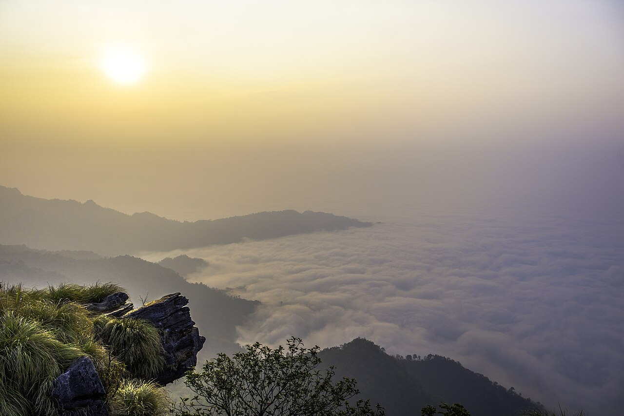
This is the sea of mist a lot of people dream about — Phu Chi Fa is a rocky cliff that juts out toward the Lao border, about 1,628 metres up, and before the sun rises a white sea of cloud fills the valley below it. When the sun breaks over the ridge, orange-gold light pours across the whole cliff face. It is genuinely worth the early start.

Honestly, almost everyone stays a night at a resort or guesthouse near the base of Phu Chi Fa, because you need to be up around 4–5 am, drive to the car park, then walk about 760 metres uphill (roughly 20–30 minutes) to reach the viewpoint in time for sunrise. The route from Chiang Rai goes through Thoeng on winding mountain roads, with no direct bus, so you drive, hire a car with a driver, or join a tour. If you're up there, swing by nearby Doi Pha Tang, another sea-of-mist viewpoint.

Getting there: Drive or hire a car with driver from Chiang Rai 2.5–3 hr via Thoeng (no direct public transport) · an overnight tour is simplest
Distance: ~90 km east of the city
Entry: The Phu Chi Fa viewpoint is free · about a 760-metre walk up to the lookout
Time needed: Stay one night near Phu Chi Fa, then up at 4–5 am for the sunrise
Tip: Bring a warm layer and a torch — the pre-dawn mountain is cold and dark · be at the car park by ~5.45 am to catch the dawn light
Best time: The sea of mist is a cool-season thing, Nov–Feb (best Dec–Jan) — clear skies, thick mist · outside the cool season your chance of mist drops sharply
🔥 Heads-up: From late cool season into Feb–Apr the burning-season haze replaces the mist — grey skies, poor visibility, bad photos. Come in the true cool season only.
🛕3
The Golden Triangle (Sop Ruak) & Chiang Saen
Where Thailand, Laos & Myanmar meet on the Mekong · ~60 km north

The point where Thailand, Laos and Myanmar meet on the Mekong is Sop Ruak, in Chiang Saen district. From the viewpoint you can see all three countries at once, with a big golden Buddha enshrined by the river, and you can take a longtail boat on the Mekong to see the three banks. Some tours include a brief stop at Don Sao market on the Lao side — be straight about it, you have to check the border paperwork and formalities with the operator first; it isn't a casual walk across.

For the region's opium history, the Hall of Opium is a large, well-told museum, or there's the smaller House of Opium near the viewpoint. Then head on to the ancient town of Chiang Saen, with its old city walls, Wat Chedi Luang and the riverside Wat Pa Sak. It works as either a half day or a full day, and it's the ideal pick if you have just one spare day.

Getting there: Drive or hire a car with driver from Chiang Rai ~1–1.5 hr · songthaews/minivans run Chiang Rai–Chiang Saen–Sop Ruak · or join a combined tour
Distance: ~60 km north of the city (via Mae Chan/Chiang Saen)
Entry: The Sop Ruak viewpoint is free · the Hall of Opium charges entry · longtail Mekong boats vary by route, check at the pier
Time needed: Half a day to a full day (Sop Ruak + Chiang Saen + Hall of Opium in one trip)
Tip: Want to cross to Don Sao on the Lao side? Check the paperwork with the operator first · the ancient town of Chiang Saen is quiet and lovely — don't rush back
Best time: Nov–Feb for cool, comfortable weather along the river · mornings bring a light mist over the Mekong · in the rains the river runs full and the banks are green
🌸4
Doi Tung, the villa & Mae Fah Luang Garden
A royal mountain project · cool-climate flower garden · arabica coffee · ~60 km northwest

Doi Tung is a lovely story — a mountain once stripped bare for opium and slash-and-burn that was turned around by a royal project into reforested slopes growing coffee and macadamia, which became the Doi Tung brand you'll see around Thailand. The highlights are the Doi Tung Royal Villa, the Princess Mother's Swiss-Lanna timber residence, and the Mae Fah Luang Garden, planted with cool-climate flowers that bloom in shifting colours through the year.

Climb to Wat Phra That Doi Tung, the old twin chedi on an open summit, then stop at the Doi Tung café for an arabica grown on the mountain with a view of the hills. Around the slopes are Akha and other hill-tribe villages who benefit from the project. The road up is winding, so bring your own car or take a tour — it pairs neatly with the Golden Triangle on the same route.

Getting there: Drive or hire a car with driver from Chiang Rai ~1.5 hr (winding mountain road) · no easy public transport · combined Doi Tung + Golden Triangle tours are common
Distance: ~60 km northwest (Mae Fah Luang district)
Entry: A combined ticket for the villa + Mae Fah Luang Garden + Hall of Inspiration (check the current price at the gate)
Time needed: A comfortable half-day-plus (villa + garden + Wat Phra That + café)
Tip: Go early to beat haze and sun · pair it with the Golden Triangle in a single day · pick up Doi Tung coffee or macadamia to take home
Best time: Nov–Feb when the garden is in full bloom, the air cool and skies clear — Doi Tung's peak · in the rains the garden is lush but you may catch a drizzle
🔥 Heads-up: Feb–Apr dry-season haze greys out the mountain views and the sky. Dust-sensitive travellers should skip this window; the garden is still fine, but the long views vanish.
💧5
Khun Korn Waterfall
Chiang Rai's tallest waterfall ~70 m · a forest walk · ~30 km southwest

If you want to escape the bustle and be among quiet forest close to town, Khun Korn Waterfall is the answer — a single ribbon of water dropping about 70 metres off a cliff, the tallest waterfall in Chiang Rai, in Khun Korn Forest Park, part of Lam Nam Kok National Park.

The charm is in the walk in — from the car park it's roughly a 1.4-kilometre walk (about 30–40 minutes each way) through bamboo and forest, a gently uphill forest trail that most people manage, shaded and cool. At the falls a curtain of cold spray hits you. The last stretch close to the water is over slippery rock, so wear trainers with good grip. There's no direct public transport — most people rent a motorbike and ride out, or charter a songthaew there and back.

Getting there: Rent a motorbike and ride ~45 min (~฿150–200/day) · charter a songthaew there and back ~฿500 · no direct bus
Distance: ~30 km southwest of the city
Entry: A small forest-park fee (check at the gate) · open 8am–5pm
Time needed: Half a day (walk in and out + a swim ~2–3 hr including travel)
Tip: Wear shoes with good grip — the last stretch is slippery · bring water and mosquito repellent · leave before evening, as it closes at 5pm
Best time: End of the rains, Sep–Nov, when the flow is strongest and the forest is green · in the cool season there's less water but the walk is comfortable · in the deep dry season (Mar–Apr) the flow can drop to a trickle
♨️6
Hot springs & hill-tribe villages
A soak near town · Akha/Lahu/Karen communities · visited responsibly

If you want an easy trip close to town that doesn't involve much walking, drop by a hot spring. The nearest is Pong Phra Bat Hot Spring in Ban Du, about 11 kilometres north of the city — Grab gets you there, and it has foot-soaking pools and affordable private bath rooms. If you're driving the Chiang Mai–Chiang Rai road (Highway 118), you'll pass Mae Khachan Hot Spring, with pools that boil at nearly 100°C — hot enough to cook an egg — a popular rest stop on the way.

Around Chiang Rai's mountains are Akha, Lahu and Karen villages, especially near Mae Salong, Doi Tung and Mae Chan. Honestly, the good way to visit is with a guide or community tour where the money reaches the villagers — buy food, crafts, tea and coffee in the village, and always ask before photographing anyone. Avoid the staged 'long-neck tour' villages that turn people into a paid exhibit; choose an experience where you genuinely talk and pay the community directly. It's far more worthwhile.

Getting there: Pong Phra Bat by Grab/car ~20 min from town · Mae Khachan is on Highway 118 between Chiang Mai and Chiang Rai (a stop en route) · hill-tribe villages via a community tour
Distance: Pong Phra Bat ~11 km north · Mae Khachan ~60 km south on Hwy 118
Entry: Pong Phra Bat private bath rooms from about ฿50/hr, massage from ~฿70 · Mae Khachan free to walk/foot-soak (buy snacks)
Time needed: 1–2 hours per spot (easy to pair with another trip on the same route)
Tip: A hot soak eases sore legs after a full day of sightseeing · for hill-tribe visits, pick operators who pay the community directly, respect the culture, and ask before photographing
Best time: The cool season, Nov–Feb, when a hot soak in cold air is best · open year-round · Mae Khachan is a handy rest stop the whole way along the Chiang Mai–Chiang Rai road
Before you go

What to know before you leave the hotel

Chiang Rai has no train and no BTS/MRT metro — the Northern Line ends at Chiang Mai, so to come by rail you take the train to Chiang Mai and then a bus or van. Getting around the province runs on your own car, a hired car with driver, a rented scooter, songthaews and tours. Be clear-eyed: most out-of-town trips are on mountain roads (Doi Mae Salong, Doi Tung, Phu Chi Fa) and are far easier with a car. The town itself is small and walkable around the clock tower and night bazaar; Grab works (supply is limited), and with songthaews and tuk-tuks you should always agree the fare before you get in. Read our full getting around Chiang Rai guide.

Plan around your spare days: with one day, take the Golden Triangle + Chiang Saen (you can add Doi Tung) — three countries, an ancient town and mountain flowers in a single day. With two days, do the northern side on day one (Golden Triangle + Doi Tung), then on day two stay near Phu Chi Fa and wake for the sea of mist, or climb Doi Mae Salong for the tea — giving you Chiang Rai's Mekong side and mountain side both. Khun Korn Waterfall and the hot springs near town make easy half-day add-ons. See the full plan in our 3 days in Chiang Rai itinerary.

🔥 Dry-season haze: the one thing we'll be straight about — from February to April (March is worst), the north burns crop fields and forest on a wide scale; Chiang Rai has posted PM2.5 averages over 100 µg/m³ (AQI often over 150), grey skies, and the mountain views and sea of mist simply disappear, with bad photos to match. Dust-sensitive travellers should avoid this stretch. The best windows are the cool season, Nov–Feb (cool, clear, clean air) and October at the end of the rains (full waterfalls, clean skies, prices still low). See the month-by-month detail in our best time to visit Chiang Rai guide, and the country picture in when to visit Thailand.

Frequently asked questions

FAQ · Day trips from Chiang Rai

Which is the best day trip from Chiang Rai?
If it's your first time in Chiang Rai and you have one spare day, the Golden Triangle (Sop Ruak) and Chiang Saen is the best call — you see where Thailand, Laos and Myanmar meet on the Mekong, the big golden Buddha, the opium museum and the ancient town of Chiang Saen all in one day, about 60 kilometres north of the city. If you love nature and don't mind an early start, Phu Chi Fa has the finest sea of mist, but you have to stay nearby and get up at 4–5 am to catch the sunrise. For tea and a Chinese-village atmosphere, choose Doi Mae Salong. All of these are best in the cool season, Nov–Feb, with clear skies and cool air — avoid Feb–Apr, when the burning-season haze is heavy.
How do I get to Phu Chi Fa from Chiang Rai, and how early do I need to start?
Phu Chi Fa is about 90 kilometres east of Chiang Rai city, a 2.5–3 hour drive via Thoeng on winding mountain roads. There is no direct bus, so the easiest options are to drive yourself, hire a car with a driver, or join a tour. Almost everyone stays a night at a resort or guesthouse near the base of Phu Chi Fa, because you need to be up around 4–5 am, drive to the car park, then walk roughly 760 metres uphill (about 20–30 minutes) to reach the viewpoint in time for sunrise over the sea of mist. Phu Chi Fa stands 1,628 metres high and is free to enter. The sea of mist is at its best in the cool season, Nov–Feb. See the plan in our 3 days in Chiang Rai.
What makes Doi Mae Salong a Chinese village, and what is there to do?
Doi Mae Salong, officially Santikhiri, in Mae Fah Luang district, is a mountain village settled by the descendants of Chinese Nationalist (Kuomintang) 93rd Division soldiers who fled Yunnan after 1949 and were later granted Thai citizenship. People here still speak Yunnanese Chinese, eat Yunnanese food (mantou buns with braised pork, Yunnan noodles) and farm high-quality oolong tea across the hillsides. The highlights are walking the tea plantations and tasting tea at the tea houses, the morning market, General Tuan's mausoleum, and the Phra Boromathat Chedi Srinagarindra on the summit. Come in late Dec to Jan and the wild Himalayan cherry blossom is in bloom. It's about 65 kilometres from Chiang Rai, a roughly 1.5-hour mountain drive, and best in the cool season.
What is at Doi Tung and the Mae Fah Luang Garden, and can you see it in half a day?
Doi Tung is a royal-project area in Mae Fah Luang district with the Doi Tung Royal Villa (the Princess Mother's Swiss-Lanna timber residence), the Mae Fah Luang Garden of cool-climate flowers in bloom year-round, Wat Phra That Doi Tung, and the Doi Tung brand's arabica coffee and macadamia. It is about 60 kilometres northwest of Chiang Rai, up a winding mountain road, so you'll want your own car or a tour. Entry is a combined ticket for the villa, garden and Hall of Inspiration (check the current price at the gate). It makes a comfortable half-day-plus, and it's best in the cool season when the flowers are full and the air is clear. It pairs well with the Golden Triangle on the same route.
Is Khun Korn Waterfall hard to reach, and how do you get there?
Khun Korn Waterfall is the tallest in Chiang Rai at about 70 metres, set in Khun Korn Forest Park about 30 kilometres southwest of the city, a 45-minute drive or motorbike ride. From the car park it's a roughly 1.4-kilometre walk through bamboo forest (about 30–40 minutes each way) on a gently uphill forest trail that most people manage fine, though the last stretch near the falls is slippery, so wear trainers with good grip. The waterfall is open 8am–5pm. There is no direct public transport — most people rent a motorbike (~฿150–200/day) or charter a songthaew there and back (~฿500). The flow is strongest at the end of the rains, Sep–Nov.
How do I visit the hill-tribe villages around Chiang Rai responsibly?
Around Chiang Rai there are Akha, Lahu and Karen villages on the mountains, especially near Doi Mae Salong, Doi Tung and Mae Chan. The good way to visit is with a guide or community tour where the money actually reaches the villagers — buy food, crafts, tea and coffee in the village, always ask before photographing people, and dress modestly. Be honest with yourself and avoid the staged 'long-neck tour' villages that turn people into a paid exhibit. Choosing an experience where you genuinely talk, learn and pay the community directly is far more worthwhile.
Klook · Day Trips

Tours from Chiang Rai — the Golden Triangle, Doi Tung and Phu Chi Fa, with a guide

Don't want to drive up the mountains yourself or juggle bus after bus? Klook has Golden Triangle + Chiang Saen tours, Doi Tung + Mae Fah Luang Garden tours, Doi Mae Salong trips, overnight Phu Chi Fa sunrise tours and the three-temple loop — transfers and entry included, out in the morning and back in the evening, nothing to figure out.

See Chiang Rai tours on Klook →
Wherebest is a Klook affiliate partner — we may earn a commission when you book through our links, at no extra cost to you.