Old town, sea, forest and a floating market — out to see the real thing
Most are close to town — with an honest note on which is half a day, a full day, and which is far enough to need travel time and the right season.
 1
1
If you only make one trip out of Hat Yai, make it Songkhla town — about 30 km east, only ~30 to 40 minutes by road. The old town still keeps long rows of Sino-Portuguese shophouses along Nang Ngam, Nakhon Nok and Nakhon Nai roads, painted in lovely pastels and dotted with street art, local cafés and Songkhla's own restaurants.
From the old town, head on to Samila Beach, where the Golden Mermaid statue is the symbol of the town — photograph it by the sea, with the Cat-and-Mouse islands (Ko Nu and Ko Maeo, two small islets shaped like a mouse and a cat) clearly out at sea behind. Honestly, it's an easy, unhurried wander, ideal if you like photography and good food, and the old town plus the beach fit neatly into one day. Read our Songkhla travel guide.
Want to see southern Thai life at a quiet pace? Ko Yo is an island in Songkhla Lake, about 30 to 40 minutes from Hat Yai, now linked by the Tinsulanonda Bridge, so you simply drive across — no boat needed. The island is known for Ko Yo woven cloth, fruit orchards, and waterside restaurants serving sea bass and seafood straight from the lake cages.
The highlight is the Institute for Southern Thai Studies (the Thaksin Folklore Museum), which keeps southern tools, textiles and ways of life on a hill overlooking the broad lake. Honestly, this trip is a slow, easy one rather than a place of big-ticket sights, but you eat fresh seafood and see a corner of Songkhla Lake that few visitors reach. It pairs with Songkhla old town in one trip, as they're on the same route.
Want good food and a market atmosphere without going far? The Khlong Hae floating market is in Hat Yai district, only about 10 km from the town centre, around 15 to 20 minutes by road. Vendors paddle boats selling southern food, local sweets and home-style dishes along the canal, with both a waterside and an on-land section to graze through.
Honestly, the market is liveliest on Friday, Saturday and Sunday evenings — on weekdays it's quiet with few stalls, so go on a weekend evening to see it at its best. Prices are low, you can sit and eat by the canal or take a boat ride along it, and it suits anyone who likes food and photos. It's the closest of all the trips to central Hat Yai.
Tired of town and craving real forest? Ton Nga Chang waterfall is the closest answer — in the Ton Nga Chang Wildlife Sanctuary, about 26 km west of central Hat Yai, around 30 minutes by road. It's a multi-tier waterfall in rainforest; the name "elephant tusks" comes from the water splitting into two streams that fall like a pair of tusks.
The lower tiers are an easy walk and you can swim, while the upper tiers mean a steady forest climb that gets harder as you go, past tall trees and birdsong along the way. Honestly, the falls are at their fullest and finest late in the rains, but the rocks are slippery then, so take particular care; in the dry season the flow drops. Bring grippy shoes and drinking water. It suits families and anyone who likes nature.
 5
5
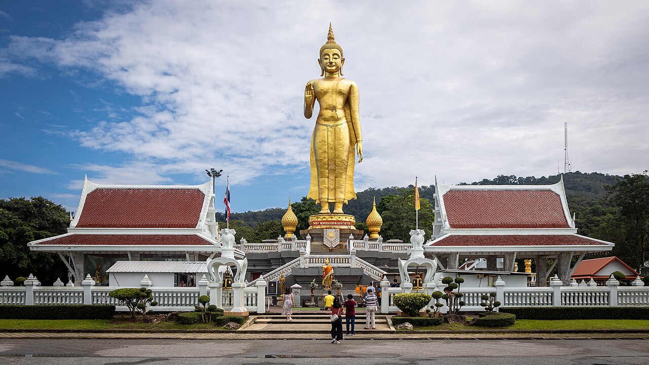
Don't want to go far but still want a view? Hat Yai Municipal Park is in town, and up on the hill the sights line up along the ridge — the highlight is Phra Buddha Mongkol Maharaj, a large golden standing Buddha with a wide view over the city. Near it stand a Brahma shrine and a large Guanyin figure to pay respects to.
You can reach the top either by driving up or by riding the cable car, with views over the city and forested hills on the way. Down below there's a water park, exercise grounds and photo spots. Honestly, it works best as a short morning or evening trip before or after the markets, with no long drive involved — kids usually love the cable car most. Check the cable-car opening hours before you go, as it closes for maintenance on some days.
 6
6
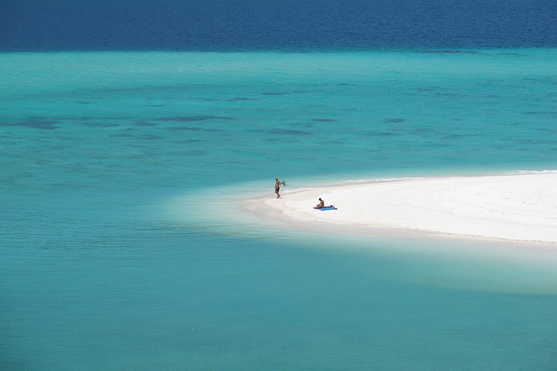
Want to go further than a usual day trip? West of Hat Yai lies Satun province, the gateway to Tarutao National Park and Ko Lipe, where the sea is exceptionally clear. Satun town and the Pak Bara pier are about 100 to 130 km from Hat Yai, around 1.5 to 2 hours by road. Honestly, if you're heading to Tarutao or Ko Lipe, one day isn't enough — you need to stay overnight, as you then take a boat out to the islands. It suits anyone with two days or more to spare.
The other option is the Malaysia border — the Sadao and Padang Besar crossings south of Hat Yai, about 1 to 1.5 hours by road. These are trade crossings and points to cross into Malaysia; many people go for border shopping or to pick up a train or coach on to Penang or Kuala Lumpur. Honestly, if you plan to cross, bring your passport and check the immigration paperwork beforehand.