🌏 Destinations · All 🇯🇵 Japan · full guide Matsumoto (Gateway) Matsumoto Attractions Takayama 🏔️ Kamikochi Guide 🧭 Travel Prep Guide About Contact 🇹🇭 ไทย🇬🇧 English🇨🇳 中文🇪🇸 Español🇫🇷 Français
🏔️ Kamikochi · Japan Alps · Nagano

Kamikochi — Alpine Valley, Kappa Bridge & the Hotaka Range

Stand in the middle of Kappa Bridge, watch the crystal-clear Azusa River flow off toward the snowy peaks of the Hotaka Range — this is the heart of the Japan Alps, a place private cars can't reach. Easy, flat walks along the water, with stops at Taisho Pond and Myojin Pond, on a day trip from Matsumoto that plenty of travellers call the most beautiful day of the trip.

Start Here

An Alpine Valley No Car Can Reach — and That's the Whole Point

Picture a 15-kilometre valley sitting at around 1,500 metres, an emerald-green river winding through pine forest, and the snowy peaks of the Hotaka Range — the highest summits of the Northern Japan Alps — standing as a backdrop. This is Kamikochi, in Nagano Prefecture, the place that has made the Japanese and hikers from all over the world fall for these mountains for more than a century. And the special part is that private cars are banned all year round to protect the environment, so everyone parks and transfers to a bus. The air stays clean, it's quiet, and there's no traffic haze blocking the view.

The good news is you don't have to be a mountaineer to enjoy Kamikochi. The main trail is a flat path along the Azusa River that you can walk in trainers — anything from a short 1-hour course to a full day on foot. This page walks you through the spots you can't miss — Kappa Bridge, Taisho Pond, Myojin Pond — explains how to get in by bus from Matsumoto or Takayama, and most importantly covers the seasonal open and closed dates that can leave you stranded if you don't know them.

🏔️ Straight up, before anything else: Kamikochi is open seasonally, only from roughly mid-April to 15 November each year (in 2026 the buses start running on 17 April, per the official site). After that it closes for a long winter — no buses, all facilities shut. Before you plan, check the latest opening date on kamikochi.org, because the date shifts a little every year.
🌲
Flat & Easy Walking
Along the river at ~1,500 m — no climbing, trainers do the job.
🚌
No Private Cars
Park at Sawando or Hirayu and transfer to a bus — that's the only way in.
🏔️
Hotaka Range Views
The highest peaks of the Northern Alps, mirrored on calm mornings.
❄️
Open Apr–Nov Only
Closed all winter, ~16 Nov to mid-April. Check before you fly.
Getting There

Everyone Comes In by Bus — Which Gateway Should You Pick?

Because private cars are banned, you park at an outer car park and transfer to a shuttle bus. There are two main gateways: the Matsumoto side (via Sawando) and the Takayama side (via Hirayu) — compare the routes below and pick the one that matches your base.

RouteSideHowTime (approx.)Notes
Matsumoto → Kamikochitrain + busMatsumotoAlpico Line train → Shin-Shimashima, then bustrain ~30 min + bus ~60 mintrain ~¥710 (cash) · bus needs a seat reservation
Sawando → Kamikochipark + shuttleMatsumotoDrive to the Sawando car park, take the shuttle busbus ~20–30 min~¥1,500 one way · buy on the day, no reservation
Takayama → Kamikochibus + transferTakayamaBus from Takayama to Hirayu Onsen, then transfer~1.5 hrs totalChange buses at Hirayu Bus Terminal
Hirayu/Akandana → Kamikochipark + shuttleTakayamaPark at Akandana, take the shuttle bus inbus ~25–30 minBest if you're touring the Takayama/Okuhida side
🚌 Key tip: since 2025, the bus on the Matsumoto/Shin-Shimashima–Kamikochi stretch requires a seat reservation in advance via the Alpico website (visit-nagano.alpico.co.jp). The shuttle buses from Sawando/Akandana can't be booked ahead — buy your ticket on the day of travel. Buses only run during the open season (17 Apr–15 Nov 2026), so check the latest timetable before you go.
6 Spots You Have to See

Walk the River and Take In the Whole Valley

Kamikochi is easy to explore because the highlights line up along a single trail beside the Azusa River — from Taisho Pond in the south, through Kappa Bridge at the centre, up to Myojin Pond in the north. Walk it short or long, whatever your legs are up for.
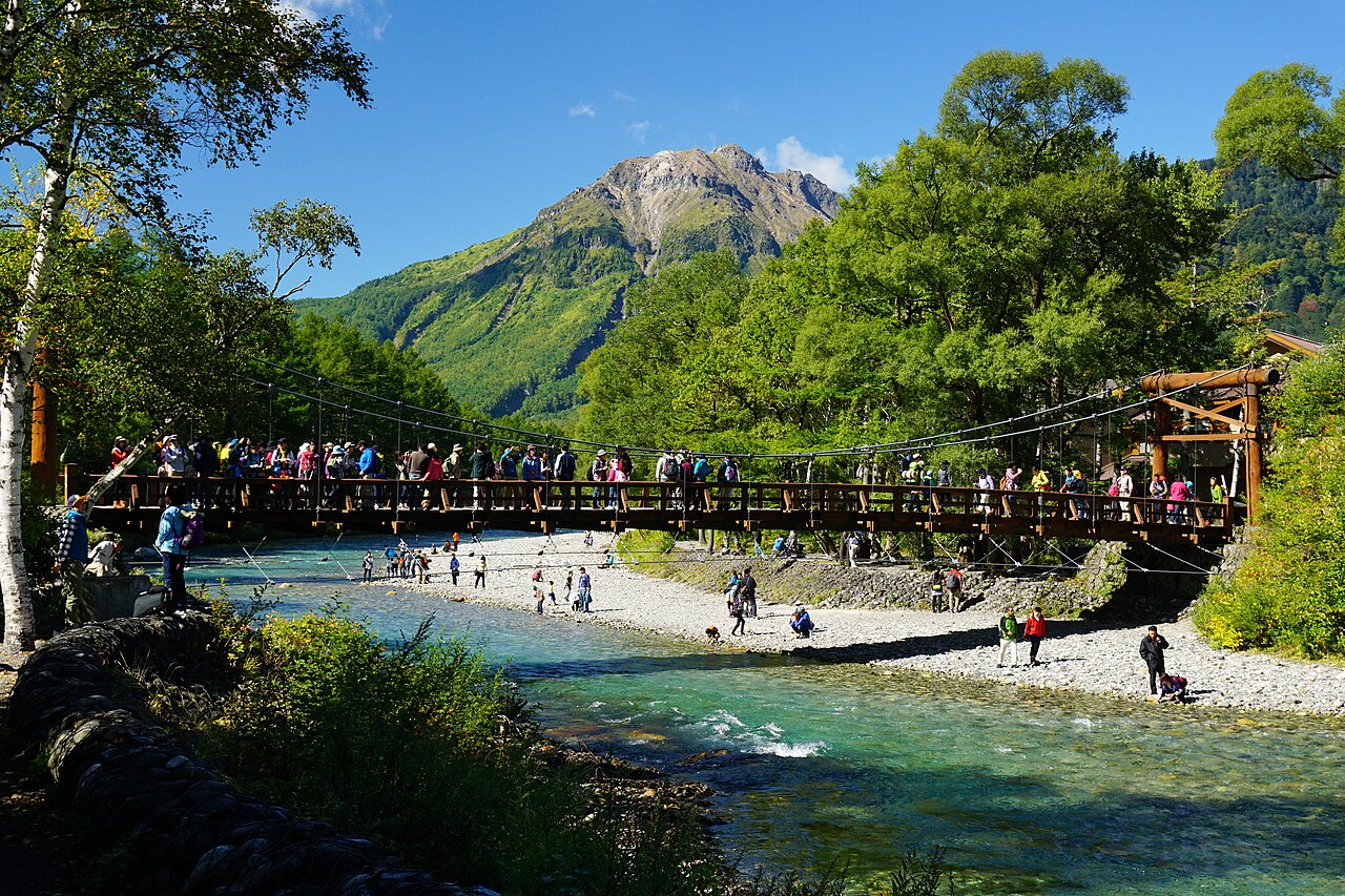
Kappa Bridge (Kappabashi) over the Azusa River, with the snowy peaks of the Hotaka Range behind it at Kamikochi 🏔️ Valley Centre1
Kappa Bridge
Kappabashi Bridge · Azusa River

The wooden suspension bridge that is the symbol of Kamikochi, spanning the Azusa River at the heart of the valley, just a few minutes' walk from the bus terminal. Stand in the middle and look upstream and you'll see the snowy peaks of the Hotaka Range filling the frame — the view that ends up on more postcards than anything else here.

📍Location: centre of the valley, near Kamikochi Bus Terminal
⏱️Walk: about 5 minutes from the bus terminal to the bridge (shortest course)
📷Highlight: the Hotaka Range upstream — the number-one photo spot
💡Tip: Come early, before the later buses arrive — fewer people and softer light.
Matsumoto Attractions →
💧 🌊 South of the Valley2
Taisho Pond
Taishō Pond · Taisho-ike

A clear marsh-lake formed when Mt. Yakedake erupted in 1915 and dammed the Azusa River, known for the dead tree trunks rising eerily out of the water. On a calm morning the Hotaka Range reflects on the surface as sharply as a mirror. Many people get off the bus at the Taisho-ike stop before heading to the centre, just to catch this spot at first light.

📍Location: southernmost end of the valley, with its own bus stop
⏱️Walk: about 1 hour along the river from Taisho Pond to Kappa Bridge
🌅Highlight: mountain reflection on still mornings + dead trees in the water
💡Tip: Mist often hangs over the water at dawn — it's most beautiful before 8 am.
Explore the Chubu Region →
⛩️ 🌲 North of the Valley3
Myojin Pond + Hotaka Shrine
Myōjin Pond · Hotaka Shrine Okumiya

Keep walking along the river north of Kappa Bridge for about an hour and you reach Myojin Pond, a still, clear lake hidden deep in the forest, with the Hotaka Shrine (Okumiya) sitting right by the water. The mood is solemn and quiet, like a sacred place. Along the way and around the pond you'll often run into troops of wild monkeys — keep your distance and there's no problem.

📍Location: north of the valley, within the Hotaka Shrine grounds
⏱️Walk: about 1 hour from Kappa Bridge (flat trail)
🎫Entry: around ¥500 (check the latest on site, may change)
💡Tip: Allow ~2 hours round trip on foot, and watch for the wild monkeys around the pond.
Matsumoto Guide →
🥾 🌲 The Whole Valley4
Azusa River Walk
Azusa River trail · Taisho–Myojin

The heart of Kamikochi is the flat walk beside the clear river running through pine forest. The stretch from Taisho Pond to Myojin Bridge is about 7 kilometres, smooth and level, with no mountaineering experience needed — trainers will do. Along the way there are rest spots, benches, and a view that keeps changing. Walking the whole thing takes about half a day.

📏Distance: Taisho–Myojin ~7 km, flat trail at ~1,500 m
⏱️Courses: short 1 hr / medium 2 hr / long 4 hr — pick to suit your legs
👟Gear: trainers are enough, no hiking boots needed
💡Tip: Walk out to the far end, then rest and amble back to catch your bus.
7-Day Japan Itinerary →
🏔️ ⛰️ For Mountaineers5
Hotaka Range + Yakedake
Hotaka Range · Mt. Yakedake

Kamikochi is the launch point for serious summit climbs in the Northern Alps, both the Hotaka Range (the highest peaks in the area) and the still gently active volcano Mt. Yakedake. These routes are a world away from the easy riverside stroll — they need planning, full gear, and often an overnight in a mountain hut. They're for people who already have hiking experience.

⛰️Level: serious mountain climbing, not the valley's flat trail
🎒You'll need: full hiking gear + planning ahead
🏕️Overnight: usually a mountain hut, book in advance
💡Tip: Beginners get plenty of stunning views just walking the valley floor.
Explore the Chubu Region →
🐒 🌲 Along the Trail6
Wildlife in the Valley
Wild monkeys & mandarin ducks

Because Kamikochi is a strictly protected national park, you've got a real chance of spotting wildlife along the trail — especially troops of Japanese macaques that often forage around Myojin Pond. Sometimes you'll see colourful mandarin ducks paddling in the Azusa River too. It's a bonus that makes the walk more fun, but remember the rules: don't feed them and keep your distance.

🐒Common sight: Japanese macaques, especially around Myojin Pond
🦆In the river: mandarin ducks and waterfowl on the Azusa
🚫Rule: never feed the wildlife, always keep your distance
💡Tip: Keep food sealed away — monkeys will snatch a plastic bag.
Japan Travel Prep →
Eat & Drink

What to Eat in the Valley — and Why to Bring Your Own

Kamikochi is a national park — there's not a single convenience store or fast-food chain. The restaurants cluster around the bus terminal and Kappa Bridge, so if you're walking far, pack some snacks and water with you.

Near the Bus Terminal
Kamikochi Shokudo

A canteen on the 2nd floor of the bus terminal serving soba, various rice bowls, pork-cutlet curry, breakfast sets, and takeaway bento boxes to eat while you walk. Open from around 6 am to 3 pm (hours vary by season).

Around Kappa Bridge
Hotel Restaurants + Local Dishes

Spots like Kappa Shokudo at the Gosenjaku hotel near the bridge let you eat with a mountain view. The local speciality is salt-grilled freshwater fish (iwana / mountain trout) skewered over charcoal, plus Nagano apple pie, the region's favourite dessert.

Before You Enter the Valley
Bring Your Own Supplies

Because there are no convenience stores in the valley, buy water, snacks, or a bento in Matsumoto or near the Sawando car park beforehand. Always carry your rubbish back out, and watch for monkeys snatching food bags when you stop to rest along the trail.

Where to Stay

Sleep in the Valley or Base in Matsumoto and Day-Trip In

Kamikochi has no big hotel chains — just a limited number of lodges and accommodations inside the valley. That's why many people choose to stay in the town of Matsumoto and visit on a day trip instead.

The first option is to stay at a lodge in the Kamikochi valley itself — there are only a handful, clustered around Kappa Bridge. The upside is waking early to walk while the mist still hangs, catching the mountain reflection on the water before the busloads of day visitors arrive. But there are few rooms in the valley and they fill up fast in high season (the autumn-leaf weeks in October), so book months ahead — and remember that after 15 November everything closes until mid-April.

What most people do is stay in the town of Matsumoto, the gateway with a wide range of hotels at more accessible prices. Wake early, take the train and bus into Kamikochi, spend the whole day, and come back to sleep. Or, if you're continuing along the Japan Alps, you can use Takayama as a base instead (entering Kamikochi from the Hirayu side) and tick off Takayama's old town on the same trip.

🏨 Booking tip: if you want to sleep in the valley, book directly with a lodge well in advance. If you're staying in Matsumoto/Takayama, you can compare rooms across several price levels before you lock one in — pick a spot near the train station so the morning bus transfer is easy.
🏔️
Lodge in Kamikochi
Only a few around Kappa Bridge, with morning and evening views day-trippers never see — but they fill up fast, so book direct and early.
🏯
Stay in Matsumoto (best for first-timers)
The gateway town with plenty of hotels at every level — train and bus into Kamikochi for the day, and Matsumoto Castle too.
🚌
Stay in Takayama (Hirayu side)
If you're continuing through the Japan Alps, use Takayama as a base to enter from the west and add Takayama's old town to the trip.
Map

The Valley Highlightson One Map

See how everything lines up along the trail beside the Azusa River — Taisho Pond in the south, Kappa Bridge and the bus terminal in the middle, Myojin Pond in the north. Plan your walk straight off this map.

Travel Tips

6 Things That Keep Your Kamikochi Trip Smooth — and You from Flying In for Nothing

❄️
Always Check the Open Season First
Open roughly mid-April to 15 Nov (2026 starts 17 Apr); closed all winter, ~16 Nov to mid-April, with no buses and everything shut. Check the latest dates on kamikochi.org.
🚌
Book the Matsumoto-Side Bus Ahead
Since 2025 the Matsumoto/Shin-Shimashima–Kamikochi bus needs a seat reservation — book on the Alpico site before you go. The Sawando shuttle is buy-on-the-day.
🌅
Come as Early as You Can
Mornings are calm with the mountains mirrored on the water, mist still rising, and fewer people than the later buses. Sleeping in the valley gives you the edge here.
🍙
Pack Water + Snacks
There are no convenience stores in the valley — buy water and food in Matsumoto or at the car park beforehand, and always carry your rubbish back out.
🧥
Pack a Warm Layer, Even in Summer
At ~1,500 m, mornings and evenings are far cooler than the lowlands. The autumn-leaf season (Oct) is colder still — bring a jacket and a windbreaker.
🍁
Pick the Season for What You Want to See
Late May–July is fresh green with alpine flowers · July–Aug is cool but the busiest · mid to late Oct is autumn colour against the snowy peaks.
Related Guides

Mountains, Nature, and the Gateway Town — Keep Planning

🏯

Matsumoto Attractions

The gateway town into Kamikochi — the legendary black-winged Matsumoto Castle, the old town, and sights around the city.

Matsumoto Attractions →
🏮

Takayama Guide

The Sanmachi old town, the morning markets, and a base into Kamikochi from the Hirayu side — the Japan Alps in one trip.

Takayama Guide →
🕯️

Koyasan Guide

The sacred mountain in Wakayama — staying overnight at a shukubo temple, the Okunoin cemetery, and shojin-ryori vegetarian cuisine.

Koyasan Guide →
💧

Oku-Nikko Guide

Kegon Falls, Lake Chuzenji, and the Senjogahara plateau — the mountain nature above the town of Nikko.

Oku-Nikko Guide →
♨️

Japan Onsen Guide

How to bathe, the etiquette, and the tattoo question every first-timer needs to know — soak away a full day of hiking.

Onsen Guide →
🇯🇵

Full Japan Travel Guide

Every region and city, with links into city guides, hotels, and attractions across Japan.

Japan Guide →
Frequently Asked Questions

Questions AboutVisiting Kamikochi

When is Kamikochi open, and does it really close for winter?
Kamikochi opens seasonally, roughly from mid-April to 15 November each year (in 2026 the buses start running on 17 April). After that it closes for a long winter, ~16 Nov to mid-April, when no buses run and all facilities are shut. Before you plan, check the latest opening date on the official site, kamikochi.org, because the date moves a little every year.
Can I drive into Kamikochi in my own car?
No. The road into Kamikochi is closed to private cars all year round to protect the environment, so everyone has to enter by bus (or taxi). If you have a car, drive to the Sawando car park (on the Matsumoto side) or Hirayu/Akandana (on the Takayama side) and transfer to a shuttle bus. The bus from Sawando takes about 20–30 minutes and a one-way ticket costs roughly ¥1,500.
How do I get to Kamikochi from Matsumoto?
Take the Alpico Line train (Kamikochi Line) from Matsumoto Station to Shin-Shimashima, about 30 minutes and around ¥710 (the ticket machines take cash only), then transfer to a bus into Kamikochi for another 60 minutes or so. There are also direct buses from Matsumoto. Since 2025, the bus on the Shin-Shimashima/Matsumoto–Kamikochi stretch requires a seat reservation in advance, so check the timetable and book on the Alpico website before you go.
Is hiking in Kamikochi hard? Do I need proper hiking boots?
The main trail along the Azusa River is flat and sits at about 1,500 metres, so it's an easy walk with no mountaineering experience needed. The path from Taisho Pond to Myojin Bridge runs about 7 km, and trainers are fine. There are short courses of about 1 hour (Bus Terminal to Kappa Bridge) up to 2–4 hour routes. Actually climbing the Hotaka Range or Mt. Yakedake is a different matter that calls for full preparation and gear.
What's the difference between Taisho Pond and Myojin Pond?
Taisho Pond was formed when Mt. Yakedake erupted in 1915 and dammed the Azusa River into a marsh. It's known for the dead tree trunks standing in the water and the reflection of the Hotaka Range on calm mornings, and it sits close to the entrance. Myojin Pond is deeper into the valley, about a 1-hour walk from Kappa Bridge, with still, clear water and the Hotaka Shrine (Okumiya) beside it. It has an entry fee of around ¥500, and you'll often see troops of wild monkeys nearby.
When is the most beautiful time to visit Kamikochi?
Late May to early July is fresh and green with alpine flowers in bloom. Summer (July–August) is cool and a good escape from the heat, but the busiest. Mid to late October is when the leaves turn yellow and red against the snowy peaks, which is stunning. Avoid weekends and long holidays if you want to dodge the crowds, and remember that after 15 November the area closes until mid-April.
Ready for the Japan Alps?

Base Yourself in Matsumoto
and Day-Trip Into Kamikochi

Open the Matsumoto guide for sights and hotels, plan to enter Kamikochi early in the morning (don't forget to check the open season and book your bus ticket), and tick off Matsumoto Castle and Takayama's old town on the same trip.

🔴 Hotels in Matsumoto Matsumoto Attractions